File:Flag map of the world.svg
Vai alla navigazione
Vai alla ricerca


Dimensioni di questa anteprima PNG per questo file SVG: 800 × 400 pixel. Altre risoluzioni: 320 × 160 pixel | 640 × 320 pixel | 1 024 × 512 pixel | 1 280 × 640 pixel | 2 560 × 1 280 pixel | 2 400 × 1 200 pixel.
File originale (file in formato SVG, dimensioni nominali 2 400 × 1 200 pixel, dimensione del file: 6,49 MB)
Dettagli
| Descrizione |
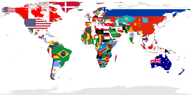
Deutsch: Eine Karte, die alle UN-Staaten mit ihrer Flagge zeigt. Das Gebiet der Westsahara ist grau eingefärbt, weil kein UN-Staat dieses Gebiet repräsentiert.
English: A map showing the flags of the world, in equirectangular projection. The countries shown are the members of the United Nations. Western Sahara is in light grey because it is considered to be a Non-Self-Governing Territory with no administration (source), therefore there is no UN member state flag to represent that place.
Español: Un mapa que muestra las banderas del mundo, en proyección equirrectangular. Los países que se muestran son miembros de las Naciones Unidas. El Sáhara Occidental está en gris claro porque se considera un territorio no autónomo sin administración, por lo tanto, no hay una bandera de un estado miembro de la ONU para representar ese lugar.
Français : Carte montrant les drapeaux du monde. Projection équirectangulaire. Les drapeaux présents correspondent aux membres des nations unies. En conséquences le sahara occidental est en gris, car considéré par l'ONU comme une territoire sans gouvernement autonome.
Українська: Мапа відображає всі країни світу, площі яких заповнені кольорами їхніх прапорів.
中文(繁體):本圖顯示的是全球聯合國會員國國家的國旗圖像,以全景圖方式顯示。非聯合國會員國的國家,不會在此圖中顯示其國旗。 |
| SVG sviluppo | Questa grossa mappa in grafica vettoriale è stata creata con Adobe Illustrator. e con Inkscape. |
| Data | |
| Fonte | Opera propria |
| Creatore | |
| Georeferencing | If inappropriate please set warp_status = skip to hide. |
| Altre versioni |
Opere derivate da questo file: |
Riconoscimenti
|

Deutsch: Dieses Bild wurde als Bild der Woche auf der tschechischen Wikipedia für die 17 Woche ausgewählt, 2018. English: This image was selected as a picture of the week on the Czech Wikipedia for 17th week, 2018. Français : Cette image est sélectionnée en tant qu’image de la semaine sur la Wikipédia Tchèque pour la 17e semaine de 2018. Italiano: Questa immagine è stata selezionata come Immagine della settimana su Wikipedia in ceco per la XVII settimana del 2018. Македонски: Сликава е избрана за слика на неделата на чешката Википедија за XVII недела од 2018 година. Русский: Эта иллюстрация была выбрана изображением недели в чешском разделе «Википедии» для недели номер 17 2018 года. Українська: Ця ілюстрація була вибрана зображенням тижня в чеському розділі «Вікіпедії» для тижня номер 17, 2018 року. |

|
Questa immagine è stata valutata secondo i criteri per le immagini di valore ed è considerata l'immagine di maggior valore su Commons per l'argomento: Flag maps of the world. Puoi vedere la sua valutazione qui. |
Licenza
| Io, detentore del copyright su quest'opera, la rilascio nel pubblico dominio. Questa norma si applica in tutto il mondo. In alcuni paesi questo potrebbe non essere legalmente possibile. In tal caso: Garantisco a chiunque il diritto di utilizzare quest'opera per qualsiasi scopo, senza alcuna condizione, a meno che tali condizioni siano richieste dalla legge. |
Cronologia del file
Fare clic su un gruppo data/ora per vedere il file come si presentava nel momento indicato.
| Data/Ora | Miniatura | Dimensioni | Utente | Commento | |
|---|---|---|---|---|---|
| attuale | 03:00, 6 gen 2023 | | 2 400 × 1 200 (6,49 MB) | wikimediacommons>JoKalliauer | Reverted to version as of 18:19, 21 December 2022 (UTC), Template:FakeSVG |
Utilizzo del file
Le seguenti 2 pagine usano questo file: