File:COVID-19 Outbreak World Map.svg

File originale (file in formato SVG, dimensioni nominali 2 921 × 1 500 pixel, dimensione del file: 1,72 MB)

|
Questo file può essere aggiornato per contenere nuove informazioni. Se si desidera utilizzare una versione specifica del file senza i nuovi aggiornamenti, è necessario caricare la versione richiesta in un file separato. |
Dettagli
| Descrizione |
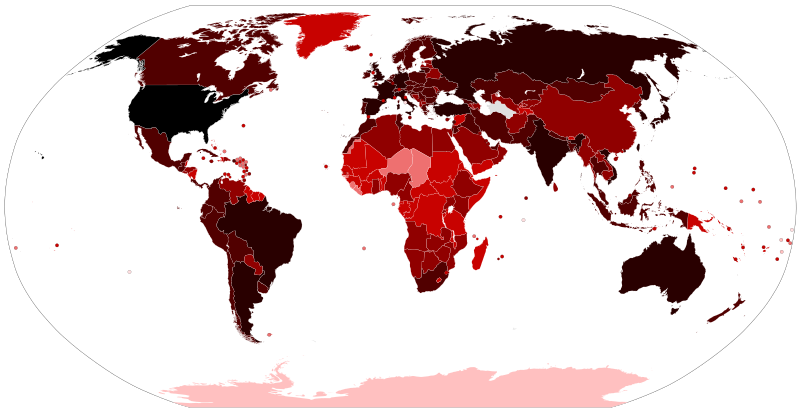
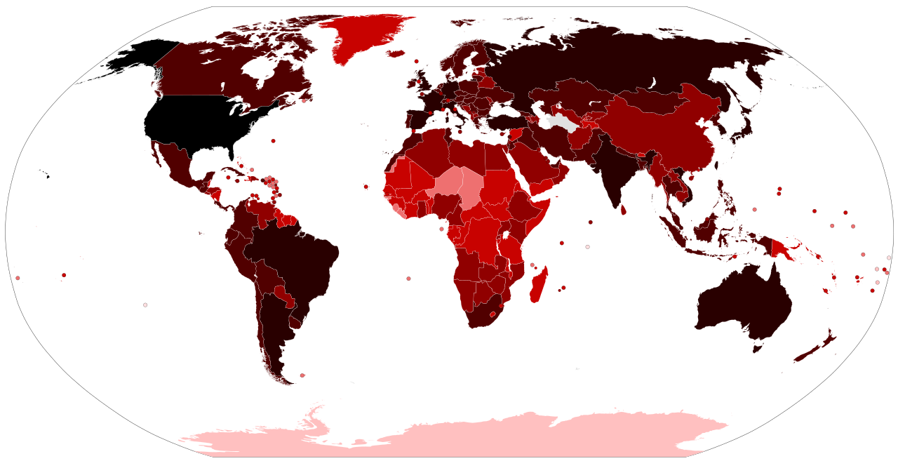
Map of the COVID-19 outbreak. Total cumulative confirmed COVID-19 cases by country. See the file history farther down for the latest upload date. Be aware that since this is a rapidly evolving situation, new cases may not be immediately represented visually. Refer to the primary article COVID-19 pandemic or the World Health Organization's situation reports for most recent reported case information. Legend information: 100,000,000+ Confirmed cases 10,000,000–99,999,999 Confirmed cases 1,000,000–9,999,999 Confirmed cases 100,000–999,999 Confirmed cases 10,000–99,999 Confirmed cases 1,000–9,999 Confirmed cases 100–999 Confirmed cases 1–99 Confirmed cases No confirmed cases, no population, or no data available |
| Data |
– Date of first upload to the Wikimedia Commons. See the file history farther down for the latest upload date. Update the "point in time" date in the Wikidata entry linked below. {{wikidata|property|Q101240885|P585}} is used in map captions on Wikipedia. It provides the map date. To enable the date change click the purge link after updating the Wikidata entry. |
| Fonte |
Latest versions: https://ourworldindata.org/explorers/coronavirus-data-explorer?tab=map&Metric=Confirmed+cases&Interval=Cumulative&Relative+to+Population=false&Align+outbreaks=false&country=~OWID_WRL - Our World in Data. Click on the download tab to download map. The table tab has a table of the exact data by country. Source tab says data is from the COVID-19 Data Repository by the Center for Systems Science and Engineering (CSSE) at Johns Hopkins University. The map at the source is interactive and provides much more detail. For example, run your cursor over the color bar legend to see the countries that apply to that point in the legend. |
| Autore |
Various Commons editors. See file history for latest ones. Older versions: Svenskbygderna (original author); Ratherous, AKS471883 (contributors); authors of File:BlankMap-World.svg (source file) |
| Altre versioni |
|
| SVG sviluppo | Il codice sorgente di questo file SVG non è valido a causa di 1 errore. Questa mappa in grafica vettoriale non valida secondo il W3C è stata creata con Inkscape. |


Licenza
- Tu sei libero:
- di condividere – di copiare, distribuire e trasmettere quest'opera
- di modificare – di adattare l'opera
- Alle seguenti condizioni:
- attribuzione – Devi fornire i crediti appropriati, un collegamento alla licenza e indicare se sono state apportate modifiche. Puoi farlo in qualsiasi modo ragionevole, ma non in alcun modo che suggerisca che il licenziante approvi te o il tuo uso.
Cronologia del file
Fare clic su un gruppo data/ora per vedere il file come si presentava nel momento indicato.
| Data/Ora | Miniatura | Dimensioni | Utente | Commento | |
|---|---|---|---|---|---|
| attuale | 16:21, 14 giu 2023 | | 2 921 × 1 500 (1,72 MB) | wikimediacommons>AKS471883 | Macao 10000 |
Utilizzo del file
Le seguenti 2 pagine usano questo file: