File:Italy and Possessions September 1939.png
Vai alla navigazione
Vai alla ricerca


Dimensioni di questa anteprima: 800 × 351 pixel. Altre risoluzioni: 320 × 140 pixel | 640 × 281 pixel | 1 425 × 625 pixel.
File originale (1 425 × 625 pixel, dimensione del file: 29 KB, tipo MIME: image/png)
Dettagli
| Descrizione |
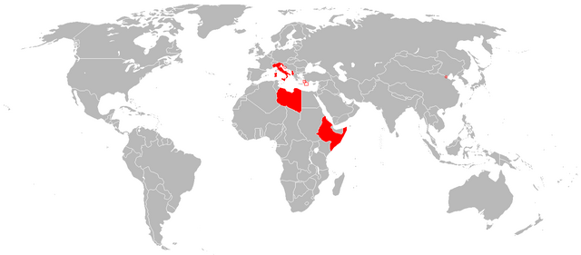
English: Italian Colonial Empire |
| Data | |
| Fonte |
|
| Autore | The Red Hat of Pat Ferrick t |
Licenza
| Quest'opera è stata rilasciata nel pubblico dominio dal suo autore, The Red Hat of Pat Ferrick di Wikipedia in inglese. Questa norma si applica in tutto il mondo. In alcuni paesi questo potrebbe non essere legalmente possibile. In tal caso: The Red Hat of Pat Ferrick garantisce a chiunque il diritto di utilizzare quest'opera per qualsiasi scopo, senza alcuna condizione, a meno che tali condizioni siano richieste dalla legge. |
Registro originale del caricamento
La pagina di descrizione originale era qui. Tutti i nomi utente che seguono sono riferiti a en.wikipedia.
- 2013-12-29 13:54 Thomas.W 1425×625× (29507 bytes) Reverted to version as of 13:02, 7 September 2010 because of deliberate manipulation of the image, adding territory that wasn't formally Italian.
- 2013-12-29 13:46 Nick.mon 1425×625× (39462 bytes) Better colors
- 2010-09-07 13:02 -kayac71- 1425×625× (29507 bytes) correction of an error in the Dodecanese border
- 2010-09-07 12:57 -kayac71- 1425×625× (29506 bytes) error in the map: the Aouzou strip was not comprised
- 2008-08-10 23:22 R-41 1425×625× (31103 bytes) Larger map showing Italy and its possessions in September 1939. Now the Italian miniscule holding in Tianjin is represented, along with red circles and outlining to show tiny areas controlled by Italy.
- 2008-06-29 15:42 The Red Hat of Pat Ferrick 344×241× (6030 bytes) {{Information |Description=Based on http://en.wikipedia.org/wiki/Image:Italian_empire_1940.PNG |Source=I created this work entirely by myself. |Date=29 June 2008 |Author=~~~ |other_versions= }} (version lost by MediaWiki)
Cronologia del file
Fare clic su un gruppo data/ora per vedere il file come si presentava nel momento indicato.
| Data/Ora | Miniatura | Dimensioni | Utente | Commento | |
|---|---|---|---|---|---|
| attuale | 18:29, 25 mag 2014 | | 1 425 × 625 (29 KB) | wikimediacommons>OgreBot | (BOT): Reverting to most recent version before archival |
Utilizzo del file
La seguente pagina usa questo file: